
Geography of Gondara: Difference between revisions
No edit summary |
No edit summary |
||
| Line 1: | Line 1: | ||
<imagemap> | |||
File:GondaraFancy_regioned_v3.png|1800px|center | |||
poly 623 202 449 250 390 351 370 429 397 604 416 684 425 793 465 650 468 561 444 495 441 442 436 412 452 369 484 324 553 283 600 262 629 253 683 226 [[Outer Vidar]] | |||
< | poly 508 670 502 754 518 916 561 1038 597 1127 677 1291 758 1437 769 1414 692 1158 610 905 568 773 [[Inner Vidar]] | ||
poly 657 250 683 350 634 415 630 507 484 599 445 460 453 379 485 329 548 296 [[Titania Region]] | |||
poly 662 1004 707 1155 821 1360 915 1327 942 1239 1016 1135 945 978 937 857 856 827 818 817 [[Wilds]] | |||
poly 995 877 1074 958 1322 789 1365 710 1344 551 1251 417 1084 303 955 271 816 253 763 268 750 316 808 356 912 377 993 445 1038 506 1081 584 1086 670 1081 733 [[Murkwoods]] | |||
poly 738 349 639 415 642 501 659 559 690 693 768 753 811 789 879 794 932 824 980 812 1011 769 1031 715 1031 665 1018 579 965 490 856 412 [[Central Plains]] | |||
poly 558 690 659 988 796 837 679 753 606 579 [[Novak Steppes]] | |||
poly 958 1315 796 1380 748 1494 844 1636 990 1567 1011 1461 [[Southern Peninsula]] | |||
poly 442 824 430 994 320 726 288 552 295 387 351 286 411 231 523 182 609 182 690 190 687 213 604 198 526 220 460 238 425 261 392 306 362 382 354 460 394 721 407 781 [[Talakar Forest]] | |||
poly 470 624 453 721 442 766 496 786 493 746 501 705 511 637 [[Titanwood Cathedral]] | |||
poly 445 769 453 1026 518 1087 551 1031 511 908 498 791 [[Talakar Strait]] | |||
poly 278 111 235 157 263 210 324 182 344 126 [[West Vantage]] | |||
poly 1277 250 1317 235 1388 268 1406 344 1370 367 1287 311 [[East Vantage]] | |||
poly 1138 1110 1090 1176 1079 1249 1128 1282 1168 1234 1198 1138 [[Embassy Island]] | |||
poly 1105 1006 981 1037 1049 1206 1100 1117 [[Delta]] | |||
desc none | |||
</imagemap> | |||
= Geography of Gondara = | = Geography of Gondara = | ||
Revision as of 01:40, 13 March 2026
Geography of Gondara
★ Foundational Canon
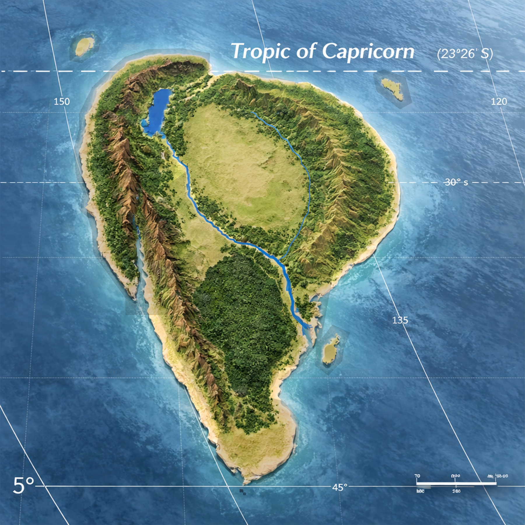
The geography of Gondara defines the physical environment upon which all Gondaran civilization, ecology, and history develop.
This document establishes the major geographic systems of the Gondaran continent and serves as the master reference for regional geography across the archive.
Continental Overview
Gondara is a large southern hemisphere continent located between approximately 25°S and 49°S latitude.
The continent occupies a geographic position between major global ocean systems, producing powerful coastal weather patterns and highly varied climatic regions.
The landmass is comparable in scale to the Indian subcontinent and contains a wide range of terrain systems including ancient mountain chains, vast plains, dense forest systems, and expansive river basins.
Several massive geological formations shape the development of the continent and influence settlement, climate, ecology, and political boundaries.
Major Geographic Systems
Several large-scale geographic systems define the structure of the Gondaran continent. These systems shape climate patterns, settlement corridors, ecological regions, and the historical development of Gondaran civilization.
The Eastern Highlands
The Eastern Highlands form a vast and ancient mountain system running along much of the eastern portion of the continent. The region is heavily forested.
The highlands act as a climatic boundary, intercepting ocean moisture and feeding numerous river systems that flow westward across the continent.
The long forested slopes of these mountains have historically supported dense woodland ecosystems and provided natural defensive terrain.
The Vidar Ranges
The Vidar Ranges form one of the most significant natural barriers on the continent.
Two major formations exist:
These ranges surround the Titania Region and help define its geographic boundaries. The Vidar systems influence regional weather patterns, migration routes, and the development of surrounding civilizations.
Several important mountain passes and corridors exist within these ranges:
- Vidar Pass — a broad lower-altitude route historically used for large-scale movement between western regions and the Titania Region.
- Wolf Creek Pass — a high-altitude and extremely dangerous route cutting through the mountains near the latitude of the Great River Delta. Travel through this corridor is difficult and often seasonal.
- Tamaron Gap — the most significant natural corridor in the northern portion of the continent. This wide gap exists between the northwestern arms of the Murkwood Forest and the northeastern extensions of the Vidar system. It forms the primary overland route connecting the interior of Gondara to the northern ocean and has historically served as a major migration, trade, and military corridor.
The Titania Region
At the center of Gondara lies Lake Titania, a massive rift lake formed by continental tectonic separation.
This basin forms the heart of the Titania Region and supports the legendary Titanwood Forests — enormous ecological systems dominated by towering tree species found nowhere else on the continent.
The Titania Region represents one of the most biologically distinctive environments in Gondara.
The Great River Basin
The Great River is the dominant hydrological system of Gondara.
Fed by numerous tributaries descending from surrounding mountain systems, the river flows across vast plains before reaching the ocean through an expansive Great River Delta.
The basin has historically supported dense settlement, agriculture, and major transportation routes.
The Great Plains
Large portions of Gondara consist of expansive plains stretching between major mountain systems.
These plains serve as agricultural centers, migration routes, and historically important strategic terrain.
They also act as transitional ecological zones between forests, mountains, and river systems.
The Southern Peninsula
The southern extension of the continent forms a long peninsula projecting toward colder southern waters.
The peninsula experiences harsher seasonal weather patterns and contains rugged coastal terrain.
Its distance from the major continental plains historically limited settlement density and contributed to the development of unique regional cultures.
Offshore Strategic Islands
Three major offshore island systems form the outer defensive perimeter of Gondara.
These islands serve as controlled gateways through which all international traffic must pass before reaching the Gondaran mainland.
They function as both military bastions and diplomatic entry points.
Geographic Influence on Civilization
The geography of Gondara has profoundly shaped the development of its civilizations.
Mountain barriers restrict movement and define cultural regions, river basins support dense population centers, and plains systems provide the agricultural heartlands that sustain Gondaran societies.
Natural corridors such as the Tamaron Gap and major mountain passes have historically served as the primary routes of trade, migration, and military movement across the continent.
Understanding the geographic structure of Gondara is therefore essential to interpreting the political, cultural, and historical development of the Gondaran world.