
Geography of Gondara: Difference between revisions
No edit summary |
No edit summary |
||
| Line 2: | Line 2: | ||
<imagemap> | <imagemap> | ||
<!-- Image Map Generated by http://www.image-map.net/ --> | |||
<img src="http://gondara-wiki.com/images/thumb/4/42/GondaraFancy_regioned_v3.png/1800px-GondaraFancy_regioned_v3.png" usemap="#image-map"> | |||
# | |||
<map name="image-map"> | |||
<area target="" alt="Outer Vidar" title="Outer Vidar" href="" coords="623,202,449,250,390,351,370,429,397,604,416,684,425,793,465,650,468,561,444,495,441,442,436,412,452,369,484,324,553,283,600,262,629,253,683,226" shape="poly"> | |||
<area target="" alt="Inner Vidar" title="Inner Vidar" href="" coords="508,670,502,754,518,916,561,1038,597,1127,677,1291,758,1437,769,1414,692,1158,610,905,568,773" shape="poly"> | |||
<area target="" alt="Titania Region" title="Titania Region" href="" coords="657,250,683,350,634,415,630,507,484,599,445,460,453,379,485,329,548,296" shape="poly"> | |||
<area target="" alt="Wilds" title="Wilds" href="" coords="662,1004,707,1155,821,1360,915,1327,942,1239,1016,1135,945,978,937,857,856,827,818,817" shape="poly"> | |||
<area target="" alt="Murkwoods" title="Murkwoods" href="" coords="995,877,1074,958,1322,789,1365,710,1344,551,1251,417,1084,303,955,271,816,253,763,268,750,316,808,356,912,377,993,445,1038,506,1081,584,1086,670,1081,733" shape="poly"> | |||
<area target="" alt="Central Plains" title="Central Plains" href="" coords="738,349,639,415,642,501,659,559,690,693,768,753,811,789,879,794,932,824,980,812,1011,769,1031,715,1031,665,1018,579,965,490,856,412" shape="poly"> | |||
<area target="" alt="Novak Steppes" title="Novak Steppes" href="" coords="558,690,659,988,796,837,679,753,606,579" shape="poly"> | |||
<area target="" alt="Southern Peninsula" title="Southern Peninsula" href="" coords="958,1315,796,1380,748,1494,844,1636,990,1567,1011,1461" shape="poly"> | |||
<area target="" alt="Talakar Forest" title="Talakar Forest" href="" coords="442,824,430,994,320,726,288,552,295,387,351,286,411,231,523,182,609,182,690,190,687,213,604,198,526,220,460,238,425,261,392,306,362,382,354,460,394,721,407,781" shape="poly"> | |||
<area target="" alt="Titanwood Cathedral" title="Titanwood Cathedral" href="" coords="470,624,453,721,442,766,496,786,493,746,501,705,511,637" shape="poly"> | |||
<area target="" alt="Talakar Strait" title="Talakar Strait" href="" coords="445,769,453,1026,518,1087,551,1031,511,908,498,791" shape="poly"> | |||
<area target="" alt="West Vatange" title="West Vatange" href="" coords="278,111,235,157,263,210,324,182,344,126" shape="poly"> | |||
<area target="" alt="East Vantage" title="East Vantage" href="" coords="1277,250,1317,235,1388,268,1406,344,1370,367,1287,311" shape="poly"> | |||
<area target="" alt="Embassy Island" title="Embassy Island" href="" coords="1138,1110,1090,1176,1079,1249,1128,1282,1168,1234,1198,1138" shape="poly"> | |||
<area target="" alt="Delta" title="Delta" href="" coords="1105,1006,981,1037,1049,1206,1100,1117" shape="poly"> | |||
</map> | |||
= Geography of Gondara = | = Geography of Gondara = | ||
Revision as of 01:38, 13 March 2026
<imagemap>
<img src="http://gondara-wiki.com/images/thumb/4/42/GondaraFancy_regioned_v3.png/1800px-GondaraFancy_regioned_v3.png" usemap="#image-map">
<map name="image-map">
   <area target="" alt="Outer Vidar" title="Outer Vidar" href="" coords="623,202,449,250,390,351,370,429,397,604,416,684,425,793,465,650,468,561,444,495,441,442,436,412,452,369,484,324,553,283,600,262,629,253,683,226" shape="poly">
   <area target="" alt="Inner Vidar" title="Inner Vidar" href="" coords="508,670,502,754,518,916,561,1038,597,1127,677,1291,758,1437,769,1414,692,1158,610,905,568,773" shape="poly">
   <area target="" alt="Titania Region" title="Titania Region" href="" coords="657,250,683,350,634,415,630,507,484,599,445,460,453,379,485,329,548,296" shape="poly">
   <area target="" alt="Wilds" title="Wilds" href="" coords="662,1004,707,1155,821,1360,915,1327,942,1239,1016,1135,945,978,937,857,856,827,818,817" shape="poly">
   <area target="" alt="Murkwoods" title="Murkwoods" href="" coords="995,877,1074,958,1322,789,1365,710,1344,551,1251,417,1084,303,955,271,816,253,763,268,750,316,808,356,912,377,993,445,1038,506,1081,584,1086,670,1081,733" shape="poly">
   <area target="" alt="Central Plains" title="Central Plains" href="" coords="738,349,639,415,642,501,659,559,690,693,768,753,811,789,879,794,932,824,980,812,1011,769,1031,715,1031,665,1018,579,965,490,856,412" shape="poly">
   <area target="" alt="Novak Steppes" title="Novak Steppes" href="" coords="558,690,659,988,796,837,679,753,606,579" shape="poly">
   <area target="" alt="Southern Peninsula" title="Southern Peninsula" href="" coords="958,1315,796,1380,748,1494,844,1636,990,1567,1011,1461" shape="poly">
   <area target="" alt="Talakar Forest" title="Talakar Forest" href="" coords="442,824,430,994,320,726,288,552,295,387,351,286,411,231,523,182,609,182,690,190,687,213,604,198,526,220,460,238,425,261,392,306,362,382,354,460,394,721,407,781" shape="poly">
   <area target="" alt="Titanwood Cathedral" title="Titanwood Cathedral" href="" coords="470,624,453,721,442,766,496,786,493,746,501,705,511,637" shape="poly">
   <area target="" alt="Talakar Strait" title="Talakar Strait" href="" coords="445,769,453,1026,518,1087,551,1031,511,908,498,791" shape="poly">
   <area target="" alt="West Vatange" title="West Vatange" href="" coords="278,111,235,157,263,210,324,182,344,126" shape="poly">
   <area target="" alt="East Vantage" title="East Vantage" href="" coords="1277,250,1317,235,1388,268,1406,344,1370,367,1287,311" shape="poly">
   <area target="" alt="Embassy Island" title="Embassy Island" href="" coords="1138,1110,1090,1176,1079,1249,1128,1282,1168,1234,1198,1138" shape="poly">
   <area target="" alt="Delta" title="Delta" href="" coords="1105,1006,981,1037,1049,1206,1100,1117" shape="poly">
</map>
Geography of Gondara
★ Foundational Canon
The geography of Gondara defines the physical environment upon which all Gondaran civilization, ecology, and history develop.
This document establishes the major geographic systems of the Gondaran continent and serves as the master reference for regional geography across the archive.
Continental Overview
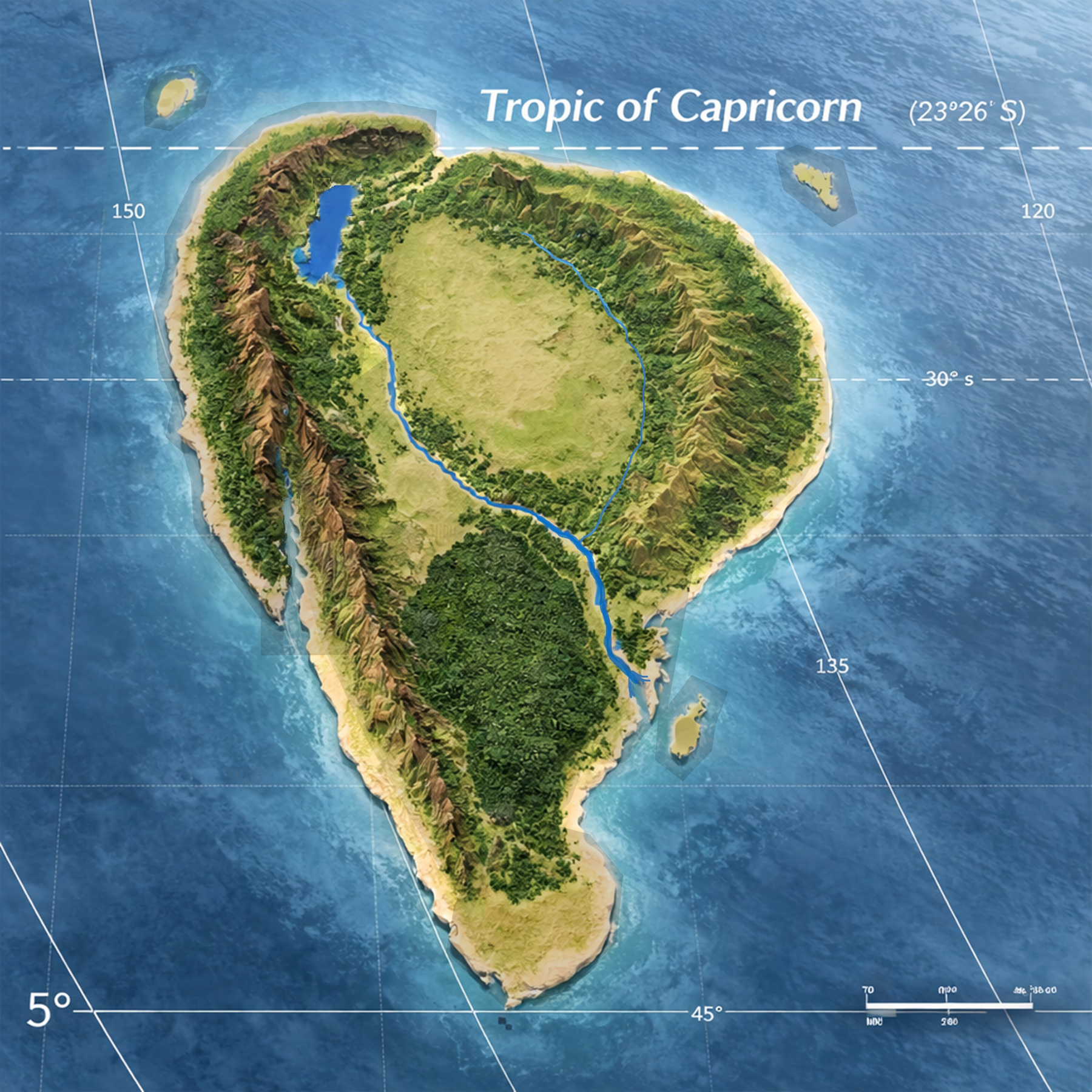
Gondara is a large southern hemisphere continent located between approximately 25°S and 49°S latitude.
The continent occupies a geographic position between major global ocean systems, producing powerful coastal weather patterns and highly varied climatic regions.
The landmass is comparable in scale to the Indian subcontinent and contains a wide range of terrain systems including ancient mountain chains, vast plains, dense forest systems, and expansive river basins.
Several massive geological formations shape the development of the continent and influence settlement, climate, ecology, and political boundaries.
Major Geographic Systems
Several large-scale geographic systems define the structure of the Gondaran continent. These systems shape climate patterns, settlement corridors, ecological regions, and the historical development of Gondaran civilization.
The Eastern Highlands
The Eastern Highlands form a vast and ancient mountain system running along much of the eastern portion of the continent. The region is heavily forested.
The highlands act as a climatic boundary, intercepting ocean moisture and feeding numerous river systems that flow westward across the continent.
The long forested slopes of these mountains have historically supported dense woodland ecosystems and provided natural defensive terrain.
The Vidar Ranges
The Vidar Ranges form one of the most significant natural barriers on the continent.
Two major formations exist:
These ranges surround the Titania Region and help define its geographic boundaries. The Vidar systems influence regional weather patterns, migration routes, and the development of surrounding civilizations.
Several important mountain passes and corridors exist within these ranges:
- Vidar Pass — a broad lower-altitude route historically used for large-scale movement between western regions and the Titania Region.
- Wolf Creek Pass — a high-altitude and extremely dangerous route cutting through the mountains near the latitude of the Great River Delta. Travel through this corridor is difficult and often seasonal.
- Tamaron Gap — the most significant natural corridor in the northern portion of the continent. This wide gap exists between the northwestern arms of the Murkwood Forest and the northeastern extensions of the Vidar system. It forms the primary overland route connecting the interior of Gondara to the northern ocean and has historically served as a major migration, trade, and military corridor.
The Titania Region
At the center of Gondara lies Lake Titania, a massive rift lake formed by continental tectonic separation.
This basin forms the heart of the Titania Region and supports the legendary Titanwood Forests — enormous ecological systems dominated by towering tree species found nowhere else on the continent.
The Titania Region represents one of the most biologically distinctive environments in Gondara.
The Great River Basin
The Great River is the dominant hydrological system of Gondara.
Fed by numerous tributaries descending from surrounding mountain systems, the river flows across vast plains before reaching the ocean through an expansive Great River Delta.
The basin has historically supported dense settlement, agriculture, and major transportation routes.
The Great Plains
Large portions of Gondara consist of expansive plains stretching between major mountain systems.
These plains serve as agricultural centers, migration routes, and historically important strategic terrain.
They also act as transitional ecological zones between forests, mountains, and river systems.
The Southern Peninsula
The southern extension of the continent forms a long peninsula projecting toward colder southern waters.
The peninsula experiences harsher seasonal weather patterns and contains rugged coastal terrain.
Its distance from the major continental plains historically limited settlement density and contributed to the development of unique regional cultures.
Offshore Strategic Islands
Three major offshore island systems form the outer defensive perimeter of Gondara.
These islands serve as controlled gateways through which all international traffic must pass before reaching the Gondaran mainland.
They function as both military bastions and diplomatic entry points.
Geographic Influence on Civilization
The geography of Gondara has profoundly shaped the development of its civilizations.
Mountain barriers restrict movement and define cultural regions, river basins support dense population centers, and plains systems provide the agricultural heartlands that sustain Gondaran societies.
Natural corridors such as the Tamaron Gap and major mountain passes have historically served as the primary routes of trade, migration, and military movement across the continent.
Understanding the geographic structure of Gondara is therefore essential to interpreting the political, cultural, and historical development of the Gondaran world.