
Southern Peninsula


The Southern Peninsula is the southernmost geographic region of Gondara, extending from the southern transition of the Wilds at approximately 40° south latitude to South Point Cape at approximately 45.2° south. The entire peninsula lies within the State of Vidara. Its estimated area is 107,299 square miles, although the exact boundary between the peninsula and the broader mainland is geographic rather than administrative.
The region combines the southern reaches of the Inner Vidar Range with broad open country and an exposed maritime coastline. Its climate is cool-temperate but demanding: strong prevailing westerly winds, fast-changing coastal weather, severe winter storms, and substantial snowfall in the northern mountains make travel and permanent settlement difficult. The lower peninsula is comparatively open, having little protection from the weather systems associated with the Roaring Forties.
As of the 1930 period, the Southern Peninsula is sparsely populated in aggregate but has a substantial military presence. Approximately seventy percent of its estimated 536,500 residents live on or around military installations and the supporting towns that have developed beside them. Joint Base Novak is a major center of population, transportation, and specialized military training. At the southern tip, South Point Artic Observation Base monitors environmental extremes and maritime traffic approaching the 50th parallel south.
Regional Structure
The peninsula begins where the southern Wilds give way to a progressively narrower landmass. Its principal geographic divisions are transitional rather than sharply bounded.
- Northern Mountain and Wilds Transition (approximately 40°–42°S) — the northern approach to the peninsula, including the southern end of the Inner Vidar system, forested foothills, valleys, and the transition from the Wilds into more open country
- Central Open Country (approximately 42°–44°S) — broad rolling grasslands, low hills, exposed uplands, and scattered woodland in more sheltered terrain; the mountain barrier becomes progressively less influential
- Southern Exposed Peninsula (approximately 44°–45.2°S) — increasingly wind-exposed grassland, heath, coastal hills, and headlands, ending at South Point Cape
These divisions describe the regional landscape and climate. They do not represent political districts or surveyed administrative boundaries.
Terrain and Landscape
Northern Mountain Country
The Inner Vidar Range reaches its southern terminus in the northern portion of the peninsula. Its steep terrain, difficult approaches, and alpine elevations distinguish this area from the more open country to the south. Forested mountain slopes and sheltered valleys give way to exposed ridges and high ground where winter conditions can become severe.
The transition around the southern end of the range is particularly important. Although the Inner Vidar mountains present a formidable obstacle to large-scale overland movement, their termination leaves a practical route around the barrier. Joint Base Novak occupies a strategic position near the western side of this southern gateway.
Central Grasslands and Valleys
South of the main mountain mass, the landscape opens into broad, rolling country. Grassland and heath are prominent across exposed sites, while woodlands are more likely to persist in sheltered valleys and favorable local conditions. The region is not assumed to be uniformly arid: open vegetation can result from persistent wind exposure, soils, drainage, and the local history of the landscape as well as rainfall.
The central peninsula offers more room for movement than the northern mountains, but weather, distance, and the limited distribution of permanent settlements continue to constrain travel and development.
Southern Coast and South Point Cape
The southern extremity is the peninsula's most exposed maritime landscape. Low coastal hills, open grassland, wind-shaped scrub, and rugged headlands meet waters affected by strong winds and passing storms. Conditions vary by coastline; exposed rocky headlands do not imply that every stretch of western shore is steep or deep-water. Parts of Gondara's western coastal approach remain comparatively shallow.
South Point Cape, at approximately 45.2°S, 138°W, marks the southernmost point of the Gondaran mainland.
Climate and Weather
The Southern Peninsula has a cool-temperate maritime climate influenced by its latitude, the surrounding Pacific, and the persistent westerly circulation of the Southern Hemisphere midlatitudes. The prevailing winds generally move from west to east. Individual storms can bring winds from other directions, but the westerly pattern is fundamental to the region's climate.
The Inner Vidar Range modifies precipitation and exposure in the north. Moist air arriving from the west can produce substantial mountain precipitation, while some terrain on the lee side may be comparatively sheltered. Farther south, where the range ends, the peninsula is more directly exposed to passing weather systems.
Winter
Winter occurs during June, July, and August and is widely regarded as the peninsula's most demanding season.
- Inner Vidar high country — deep snow in suitable elevations, hard freezes, whiteouts, dangerous ice, and avalanche-prone mountain terrain
- Joint Base Novak training country — cold-weather field conditions, snow and ice in the mountains, and severe exposure during winter exercises
- Central open country — frosts, cold winds, periods of sleet or snow, and occasional disruptive winter storms
- Southern coast and South Point — strong winds, cold rain, heavy seas, and periods of freezing or snowy weather during colder outbreaks
The harshness of these winters is not defined by uninterrupted deep snow across the lowlands. Wind, wet conditions, rapidly changing weather, and isolation can make even above-freezing conditions hazardous, while the mountains provide substantially colder and snowier environments.
Other Seasons
Spring and autumn are changeable, with passing fronts, shifting temperatures, and frequent winds. Summers are generally milder than those of Gondara's warmer northern regions, although sheltered inland locations can experience warmer spells. Local conditions differ considerably between mountain valleys, open grasslands, and exposed coasts.
Hydrology and Coastal Conditions
The northern highlands support local streams and drainage valleys fed by precipitation and, seasonally, by mountain snowmelt. The peninsula's smaller watercourses have not yet been assigned a comprehensive named river system in the geographic record.
Coastal conditions are an important constraint on navigation and development:
- Strong westerlies and rapidly changing weather can complicate coastal operations
- Exposed southern waters experience rough seas and dangerous surf during storms
- Shallow areas along the western approaches affect navigation and military landing considerations
- The southwestern offshore continental shelf is important to Gondara's early petroleum exploration
The coastline should not be treated as uniformly cliff-bound or uniformly sheltered; exposure, depth, and local terrain vary around the peninsula.
Ecology
Vegetation changes substantially from north to south. The region's working ecological profile combines elements of Pacific Northwest uplands and southern New Zealand's cool, windswept maritime landscapes.
- Northern forests — substantial forest cover in the wetter foothills and sheltered mountain valleys
- Central grasslands — open grasses and low vegetation across broad exposed slopes, with woodland pockets in protected ground
- Coastal heath and scrub — low, wind-resistant vegetation on exposed southern headlands and coastal uplands
- Alpine environments — cold-tolerant vegetation and seasonally snow-covered terrain at higher elevations of the Inner Vidar Range
These are broad habitat descriptions rather than a finalized inventory of Gondaran plant or animal species. Specific flora, fauna, and regional ecological boundaries remain subject to the Gondaran ecology records.
Human Geography and History
Indigenous and Precolonial History
The peninsula contains one of the unresolved questions of Gondara's early human history. Scattered traditions preserved among the Mera'kai and Novak refer to a substantial people who once lived south of the Wilds. Their name, settlements, material culture, and fate are not firmly established in the surviving record.
One historical interpretation holds that repeated Kael’Ruun incursions may have destroyed, enslaved, or absorbed this population over generations. In this interpretation, the Wilds to the north and the ocean surrounding the peninsula limited opportunities for retreat. This remains a hypothesis, not a proven historical conclusion. The scarcity of archaeological evidence does not establish precisely when or how the people disappeared.
Colonial Period and Exploration
European colonial knowledge of the Southern Peninsula remained limited. Colonists did not substantially explore the region before Gondaran unification, and the absence of detailed colonial accounts should not be mistaken for evidence that the peninsula was uninhabited.
Exploration was sporadic during the early nineteenth century and became more systematic around the middle of that century. The difficult weather, remote terrain, limited access, and hazards associated with the northern Wilds contributed to the region's slow documentation and development.
The 1930 Period
By 1930 the Southern Peninsula forms part of the State of Vidara. It remains thinly settled outside military-centered communities, but is increasingly connected to the rest of Gondara through established rail lines and highway construction. The government is encouraging further permanent settlement even as military training and observation continue to dominate the region's largest population centers.
Population and Settlement Patterns
The peninsula's population density is estimated at approximately five persons per square mile in the 1930 period. Applied to the working regional area of 107,299 square miles, this gives a total population of approximately 536,500. The figures are rounded estimates rather than a finalized census enumeration.
Estimated Distribution
- On or around military bases and their supporting towns: approximately 70%, or 375,550 people
- Elsewhere on the peninsula: approximately 30%, or 160,950 people
The larger category includes military personnel as well as families, civilian workers, merchants, railway employees, and other residents of communities whose location and economic activity are closely tied to nearby installations. It does not mean that 70% of the population consists of active-duty servicemembers, nor that all these residents live within military-base boundaries.
Settlement Logic
Population is heavily concentrated rather than evenly distributed. Common patterns include:
- Major base towns — especially the civilian and military settlement concentration at Joint Base Novak
- Secondary military communities — other installations and their surrounding support settlements, whose individual names and populations have not yet been established
- Rail-linked settlements — communities associated with transportation, maintenance, supply, and movement through the region
- Rural and coastal settlements — scattered communities outside the military-centered population network
Large stretches of countryside remain very lightly inhabited. The numerical average of five residents per square mile therefore conceals a sharp contrast between busy military towns and sparsely settled open country.
Military Installations
Military activity is a defining feature of the modern Southern Peninsula, although the installations are not all of the same size or purpose.
Joint Base Novak
Joint Base Novak is a major joint-service military installation located on the western side of the southern terminus of the Inner Vidar Range. It supports the Gondaran Army, Navy, Air Force, Marine Corps, and Coast Guard, and is one of the peninsula's principal population and transportation centers.
Its foremost training specializations are cold-weather operations and mountaineering. The surrounding terrain permits instruction in:
- Mountain climbing, movement, and navigation
- Operations in snow, ice, and severe winter weather
- Survival, field endurance, and equipment performance in cold conditions
- Mountain reconnaissance and rescue
- Joint-service operations in difficult terrain and weather
Novak also serves a distinct defensive purpose. The Inner Vidar Range is exceptionally difficult for large military formations to cross; consequently, a hostile landing along Gondara's relatively shallow western approaches could seek to advance around the range's southern end. The base guards this potentially important southern route into the interior.
Three established railroad approaches converge at Joint Base Novak. Highways are being built alongside these rail corridors during the 1930s, reinforcing the base's logistical role and the surrounding town's importance.
The installation takes its name from the Novak people. Gondaran joint bases follow a tradition of naming such installations after the original tribes; Novak was the remaining tribal name when this base was named. The Novak are also remembered as the only tribe known to have crossed Wolf Creek Pass and reached Gondara's western or southwestern coast.
South Point Artic Observation Base
South Point Artic Observation Base is located at the extreme southern end of the peninsula near South Point Cape. It is operated primarily by the Coast Guard and Navy and has a specialized mission distinct from Joint Base Novak's training and regional-defense responsibilities.
Its primary mission is the observation and study of environmental extremes, including severe weather, high winds, ocean conditions, and hazards affecting operations in Gondara's southern waters. Its secondary mission is monitoring maritime traffic proceeding toward or returning from the 50th parallel south.
The base's position makes it valuable for southern weather observation and maritime awareness. Its permanent population, facilities, and supporting settlement have not yet been defined.
Other Installations
Joint Base Novak and South Point are the two specifically identified installations in the current regional account, not the peninsula's only bases. Other military installations and their support communities contribute to the concentration of population around the peninsula's military network. Their names, missions, and population totals remain to be established.
Transportation and Access
The peninsula's transport system is shaped by the northern mountain barrier, the open but sparsely settled southern terrain, and military logistical requirements.
- Railroads — three established lines converge at Joint Base Novak, forming a major transportation junction
- Highways — road construction is proceeding alongside those established rail corridors during the 1930s
- Mountain routes — steep terrain and winter weather restrict travel near the Inner Vidar Range
- Open-country routes — the more accessible southern landscape still faces long distances, strong winds, and relatively little settlement infrastructure
- Coastal access — useful for maritime movement and observation, but sensitive to local water depth and severe weather
These transport corridors connect substantial population centers without creating an evenly developed network across the whole peninsula.
Resources and Economic Development
Land-Based Potential
The northern forests, sheltered valleys, and open grasslands provide different opportunities for timber use, agriculture, and livestock grazing where local conditions permit. Such opportunities should not be mistaken for an already extensive civilian agricultural economy: settlement outside military-centered communities remains limited, and the suitability of individual districts is still being assessed.
Southwestern Offshore Petroleum
Geological surveys southwest of the peninsula have identified evidence of very large offshore petroleum and natural-gas deposits. Current estimates suggest that the potential resource may equal at least twice the estimated petroleum reserves of Greyvale, Gondara's principal established onshore oil-producing region.
This comparison concerns estimated geological potential, not proven commercially recoverable reserves or production already achieved. Surveys also suggest that richer concentrations may exist farther offshore in deeper waters, where confirmation and extraction would be considerably more difficult.
During the 1930s, Gondara is experimenting with costly offshore drilling and production techniques on portions of the comparatively shallow continental shelf. Work is constrained by available technology, investment requirements, and the strong winds and rough seas affecting the southwest approaches. The full economic importance of these deposits is not yet apparent to contemporary observers.
For the broader national resource context, see Mineral Analysis of Gondara.
Strategic Significance
The Southern Peninsula is important to Gondara for several overlapping reasons:
- Southern mountain gateway — Joint Base Novak protects the route around the southern end of the Inner Vidar Range
- Specialized military training — winter conditions and alpine terrain support cold-weather operations, mountaineering, and rescue instruction
- Southern maritime observation — South Point monitors environmental extremes and traffic moving toward the 50th parallel south
- Transportation concentration — the railway junction at Novak and associated highway program connect key military and settlement centers
- Offshore resource potential — southwestern petroleum and natural-gas prospects may become strategically important, although commercial recovery remains uncertain in 1930
- Frontier settlement — government settlement efforts aim to build a broader permanent population beyond established military-centered communities
Unlike regions whose primary importance lies in dense agriculture or established industry, the Southern Peninsula is defined by the interaction of difficult weather, military infrastructure, limited civilian settlement, and substantial long-term resource potential.
Landscapes of the Southern Peninsula
The following images are illustrative landscape reconstructions, intended to communicate the regional terrain and climate. They are not surveyed photographs or authoritative geographic maps.
-
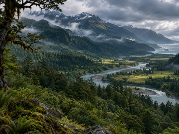 Northern mountain and Wilds transition: forests, river valleys, and Inner Vidar high country
-
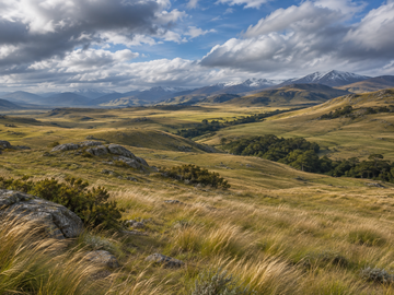 Central open country: rolling grasslands, scattered sheltered woodland, and distant uplands
-
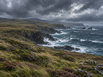 Southern coast: windswept heath, rocky headlands, and storm-driven seas
-
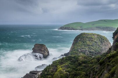 South Point Cape: exposed southern grasslands and the stormy Pacific


